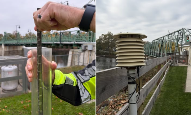
Did you know? Delaware River bridge employees help track weather conditions and monitor potential flooding

NEW JERSEY — Did you know that employees who operate and maintain bridges along the Delaware River also help the National Weather Service track rainfall, snowfall, temperatures and river conditions that can play an important role in flood forecasting?
For more than two decades, the Delaware River Joint Toll Bridge Commission has collected daily weather observations at three bridges connecting New Jersey and Pennsylvania, providing valuable information to the National Weather Service’s forecasting office in Mount Holly.

The measurements are taken at the Easton-Phillipsburg (Route 22) Toll Bridge, Riegelsville Toll-Supported Bridge and Riverton-Belvidere Toll-Supported Bridge, where commission employees record rainfall, snowfall and maximum and minimum temperatures.
Although the practice had been in place for more than 20 years, it was not formally documented until June 30, 2025, when the commission entered into a cooperative agreement with the National Weather Service. The agreement, announced in July 2025, established a formal framework for the commission’s longstanding weather data collection activities.
Commission employees use equipment supplied by the National Weather Service, including an eight-inch standard rain gauge, a snow-measuring board, a snow-measuring stick, a maximum/minimum temperature sensor and a Nimbus Temperature Display Unit. The readings are collected daily and submitted to National Weather Service forecasters through an online reporting form or by telephone.
The information serves several purposes, including helping meteorologists and hydrologists monitor weather conditions and assess potential flooding along the Delaware River.
Daily precipitation measurements are used by the National Weather Service’s Mid-Atlantic River Forecast Center, which monitors potential flooding and prepares river-condition forecasts for recreational users and others who depend on information about waterways.
The observations also contribute to the National Weather Service’s historical weather records, which date back to the 1980s for the Riverton-Belvidere and Riegelsville locations and to 1994 for the Easton-Phillipsburg Toll Bridge.
According to the commission, these historical records are used for research, insurance claims and emergency declarations by the Federal Emergency Management Agency.
Bridge equipment also tracks Delaware River levels
In addition to collecting daily weather observations, the Delaware River Joint Toll Bridge Commission has a separate arrangement with the U.S. Geological Survey’s New Jersey Water Science Center to monitor water levels along the Delaware River.
The river-monitoring partnership, which had been in place for approximately 18 years when the commission issued its July 2025 announcement, involves electronic river-level measuring devices installed at five bridges.
Under the arrangement, the U.S. Geological Survey operates and maintains the equipment, while the commission covers installation, telecommunications and power costs.
The five bridges equipped with the monitoring devices are:
- Easton-Phillipsburg (Route 22) Toll Bridge
- Uhlerstown-Frenchtown Toll-Supported Bridge
- Centre Bridge-Stockton Toll-Supported Bridge
- New Hope-Lambertville Toll-Supported Bridge
- Washington Crossing Toll-Supported Bridge
The devices use radar technology to measure the Delaware River’s height every 15 minutes, with the information transmitted by satellite every hour to the National Weather Service.
The data supports the National Weather Service’s river forecasting operations, helping meteorologists and hydrologists monitor changing water levels and providing information that communities can use for flood warnings and emergency response activities.
The river-level monitoring arrangement is separate from the commission’s cooperative agreement with the National Weather Service for daily precipitation and temperature readings.
Together, the two longstanding efforts demonstrate how bridge operations along the Delaware River contribute to regional weather monitoring, historical data collection and flood preparedness.